General News
28 February, 2021
Cairns cops a drenching
Mon: Feb 1 - A wild weather day takes its toll in Cairns and the Far North
18:00 Monday Mar 1
Cairns continues to cop a soaking as a rain front passes offshore.
The tropical low continues to move north past Cairns bringing wind and lashing rain to the city and region.
More than 42,000 homes lost power this afternoon, a full list of Ergon Outages can be found here.
An Ergon Energy spokeswoman said "crews were responding to weather-related power outages but would likely be delayed by poor weather and localised flooding.
She said "crews’ priority would be to make the area safe for the community before starting emergency network repairs to restore power.
"The outages spread from Kuranda, across Cairns, out to the Tablelands and south to Tully."
Catholic Schools to be closed tomorrow (Tuesday)
Most Catholic Schools across te region will be closed on Tuesday due to weather conditions.
The Catholic Education Diocese of Cairns posted the following message on their Facebook page this afternoon.
School closures Tuesday 2 March
All Catholic schools in the Cairns, Mossman, Cooktown, Tablelands and Cassowary Coast regions will be closed tomorrow, Tuesday 2 March due to the current cyclonic conditions caused by the tropical low which is slow moving off the coast.
The only far northern Catholic schools to remain open will be St Joseph’s Parish School, Weipa and Our Lady of the Sacred Heart School, Thursday and Hammond Islands.
Boarding schools in Cairns, Herberton and Cooktown will have arrangements in place to care for boarding students.
Catholic Early Learning and Care Outside School Hours Care services and Long Day Care services will also be closed tomorrow.
It is expected that all schools will reopen on Wednesday, however that will be reassessed Tuesday afternoon and updated advice will be provided if schools will not be reopening.
Catholic Education Services Cairns Executive Director Bill Dixon said the decision was made in the interests of the safety of students, families, staff and all in the community. 'Stay home on Tuesday and stay safe," he advised.
COUNCIL FACILITIES CLOSE
Cairns Regional Council issued a notice at 2.12pm on Monday to advise of multiple facility closures due to weather.
Closures are in place until further notice.
Council facilities:
Gordonvale and Babinda Waste Transfer Stations.
All Active Living classes are cancelled.
Tobruk Memorial Pool, Gordonvale and Babinda pools.
Sugarworld Parklands, Gordonvale
Lake Morris Rd
Esplanade Lagoon, Muddy’s Playground, and Esplanade Activity Precinct (skate park, volleyball courts, boundering park, half-court).
The following parks and sporting fields are closed:
Johnson Park, Gordonvale Alley Park, Gordonvale
Petersen Park, Edmonton
Bill Wakeham Park, Babinda
Barlow Park
12noon Monday Mar 1
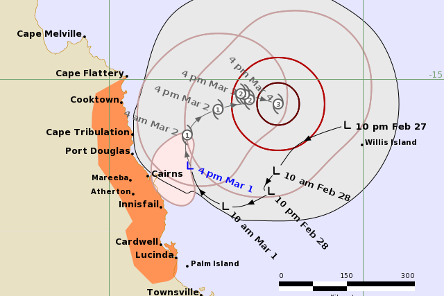
The low weather system currently off the east coast from Cairns continues to defy prediction.
Positioned 175 kilometres off the coast from Cairns, and moving southeast at 8 kilometres an hour, the system is bringing good rain to the North.
The tropical low is expected to remain slow-moving while continuing to develop today. It is expected to reach tropical cyclone strength during Tuesday.
Direct impact from the centre of the cyclone moving onto the coast is unlikely, however the system may remain close enough to the coast to cause gales about exposed coastal fringes and island communities.
The cyclone is likely to remain off the coast while intensifying over the next two days. In the longer term, it is likely to take a southeasterly track away from the coast as a category 3 cyclone.
05:30 Monday Mar 1
This morning the Bureau of Meteorology issued an update stating a direct coastal impact was not expected, however gales were possible around exposed coastal and island areas.
The system is currently approximately 250 kilometres east of Cairns and building in intensity.
The advise from the Bureau stated, "the tropical low has been near-stationary off the north tropical coast in the past 12 hours, and is expected to remain slow-moving while continuing to develop today and Tuesday.
"It is expected to reach tropical cyclone strength on Tuesday morning. Although a direct coastal impact by the centre of the cyclone is unlikely, the system may approach close enough to the coast to produce gales about exposed coastal and island areas from the latter part of Tuesday.
"Heavy rainfall is also likely about the coast and nearby ranges.'
The Bureau anticipates the system will a southeasterly track later this week whilst remaining offshore.
19:00 Sunday Feb 28
The low pressure system continues to move southwest at 8 kilometres per hour, and is currently 250 kilometres east of Cairns.
Residents are advised to take the necessary steps should the system intensify.
Residents are also advised to visit the Cairns regional Council Disaster Dashboard for up-to-date information.
The latest update from the Bureau of Meteorology, issued today (Sunday) at 11:33am said the system is about 270km east of Cairns and is expected to be upgraded to a cyclone on Tuesday morning.
“Although a direct coastal impact is not expected, gales are possible about exposed coastal and island areas as the system reaches cyclone strength. Heavy rainfall is also likely,” the latest forecast said.
“People between Cape Flattery and Lucinda, including Port Douglas, Cairns, and Innisfail, should consider what action they will need to take if the cyclone threat increases.”
Heavy rainfall could develop on the coast and inland over the next few days and a flood watch is currently in place between Mission Beach and Townsville.
Gales of up to 100km/h could develop as the system intensifies.
Abnormally high tides are also predicted.
The system is currently moving southwest at 15km/h.
