General News
2 January, 2021
UPDATED: Tropical cyclone Imogen weakens to a tropical low.
Cyclone Imogen is downgraded to a tropical low
UPDATED:
Monday 11:00 4-1-21
Ex-Tropical Cyclone Imogen weakens to a topical low
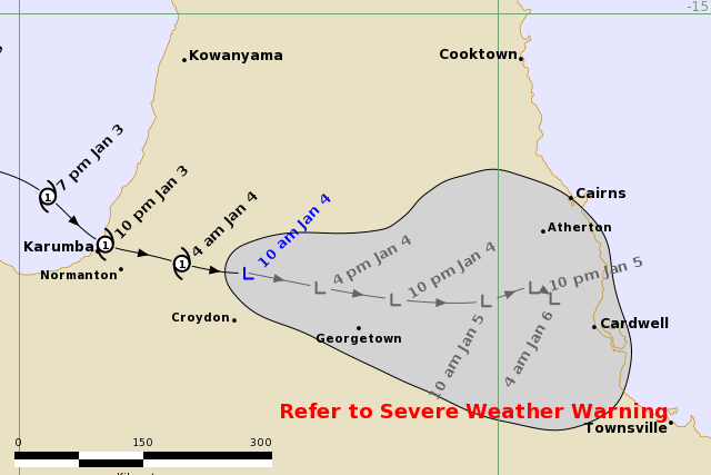
Tropical cyclone Imogen has weakened to a tropical low but remains a dangerous system with widespread flooding rainfall expected over northern Queensland.
As it tracks east southeast, ex-tropical cyclone has weakened and now is classified as a tropical low.
Still with winds near the centre of 55 kilometres an hour and wind gusts up to 85 kilometres an hour.
The tropical low is still moving across the Gulf Country at 14 kilometres an hour . The system is expected to track more slowly to the southeast towards the North Tropical and Herbert-Lower Burdekin coasts
Next update is scheduled for 2pm today.
UPDATED:
Monday 07:00 4-1-21
Tropical cyclone Imogen cross the Queensland coast north of Kurumba last night and has continued to move at 19 kilometres an hour in a east southeast direction over the eastern Gulf Country.
Categorised as an category 1 cyclone, Imogen has sustained winds near the centre of 65 kilometres an hour and wind gusts up to 95 kilometres an hour.
The system has recently maintained its strength over land, but later this morning is expected to gradually transition to a tropical low. Longer term, the system is expected to track more slowly to the southeast towards the North Tropical and Herbert-Lower Burdekin coasts as a deep tropical low.
Next update, #13 will be issued later this morning
RELATED: Get your supplies ready
UPDATED
Sunday 06:00 3-1-21
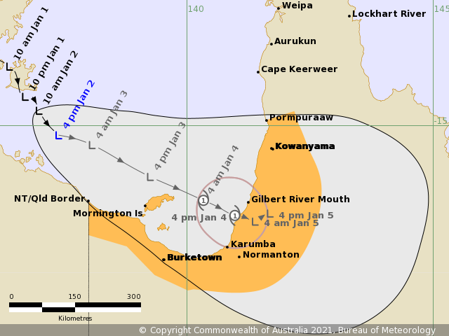
The tropical low in the southern Gulf of Carpentaria continues to move steadily east south east towards the southeast gulf coast.
Moving at 12 kilometres an hour the tropical low may intensify into a Category 1 cyclone in the early hours of tomorrow (Monday), before crossing the coast potentially north of Karumba.
Gales extending out to about 100 kilometres from the centre of the cyclone may develop about coastal and island communities between NT/Qld Border and Pormpuraaw early Monday morning.
Abnormally high tides and large waves are expected about the southeastern Gulf and western Cape York Peninsula as the cyclone approaches the coast. Large waves may produce flooding along the foreshore.
Heavy rainfall that is likely to lead to flash flooding, flooding of low lying areas and riverine flooding will develop about the southeast Gulf of Carpentaria coast and adjacent inland later today and spread to remaining areas of southern Cape York Peninsula on Monday as the low or tropical cyclone moves onto the coast and further inland.
Next update is scheduled for 11:00 am Sunday
Sat 17:00 2/1/21
Headline:
A tropical low over the western Gulf of Carpentaria is expected to move east-southeast and intensify during Sunday.
Areas affected:
Warning zone: None.
Watch zone: NT/Qld Border to Pormpuraaw.
Cancelled zones: None.
Details of Tropical Low at 4:00 pm AEST:
Intensity: tropical low, sustained winds near the centre of 45 kilometres per hour with wind gusts to 85 kilometres per hour.
Location: within 55 kilometres of 15.2 degrees South, 137.4 degrees East , 165 kilometres north northwest of NT/Qld Border and 250 kilometres northwest of Mornington Island .
Movement: southeast at 9 kilometres per hour .
The tropical low may develop into a tropical cyclone during Sunday night over the far southern Gulf of Carpentaria, near Mornington Island.
The tropical cyclone is expected to continue moving southeastwards crossing the southeastern Gulf coast during Monday.
Hazards:
GALES extending to 100 kilometres from the centre of the tropical low or cyclone are expected to develop about coastal and island communities between NT/Qld Border and Kowanyama during Sunday night.
ABNORMALLY HIGH TIDES and large waves are expected about the southeastern Gulf and western Cape York Peninsula as the cyclone approaches the southern Gulf coast.
HEAVY RAINFALL may lead to flash flooding, flooding of low lying areas and riverine flooding about the southeastern Gulf of Carpentaria, southern Cape York Peninsula and adjacent inland areas from Sunday onwards. A Flood Watch is current for the area.
Recommended Action:
People between NT/Qld Border and Pormpuraaw should consider what action they will need to take if the cyclone threat increases.
- Information is available from your local government
- For cyclone preparedness and safety advice, visit Queensland's Disaster Management Services website (www.disaster.qld.gov.au)
- For emergency assistance call the Queensland State Emergency Service (SES) on 132 500 (for assistance with storm damage, rising flood water, fallen trees on buildings or roof damage).
Next Issue
The next Forecast Track Map will be issued by 11:00 pm AEST Saturday
Sat 2/1/21 11am
A tropical low over the western Gulf of Carpentaria is expected to move east-southeast and intensify during Sunday.
Areas affected:
Warning zone: None.
Watch zone: NT/Qld Border to Pormpuraaw.
Cancelled zones: None.
Details of Tropical Low at 10:00 am AEST:
Intensity: tropical low, sustained winds near the centre of 35 kilometres per hour with wind gusts to 75 kilometres per hour.
Location: within 55 kilometres of 14.7 degrees South, 137.0 degrees East , 230 kilometres north northwest of NT/Qld Border and 315 kilometres northwest of Mornington Island .
Movement: southeast at 7 kilometres per hour .
The tropical low may develop into a tropical cyclone during Sunday night over the far southern Gulf of Carpentaria.
The tropical low or cyclone is expected to move southeastwards and cross the southeastern Gulf coast during Monday.
Hazards:
GALES extending to 100 kilometres from the centre of the tropical low are expected to develop about coastal and island communities between NT/Qld Border and Kowanyama during Sunday night.
ABNORMALLY HIGH TIDES and large waves are expected about the southeastern Gulf and western Cape York Peninsula as the system approaches the coast.
HEAVY RAINFALL that may lead to flash flooding about the southeastern Gulf of Carpentaria, southern Cape York Peninsula and adjacent inland areas.
Recommended Action:
People between NT/Qld Border and Pormpuraaw should consider what action they will need to take if the cyclone threat increases.
- Information is available from your local government
- For cyclone preparedness and safety advice, visit Queensland's Disaster Management Services website (www.disaster.qld.gov.au)
- For emergency assistance call the Queensland State Emergency Service (SES) on 132 500 (for assistance with storm damage, rising flood water, fallen trees on buildings or roof damage).
Tropical Cyclone information is also available in MetEye
Next Issue
The next Forecast Track Map will be issued by 5:00 pm AEST Saturday
