Community
22 January, 2024
UPDATE: 9.30am Tropical Cyclone Kirrily officially named
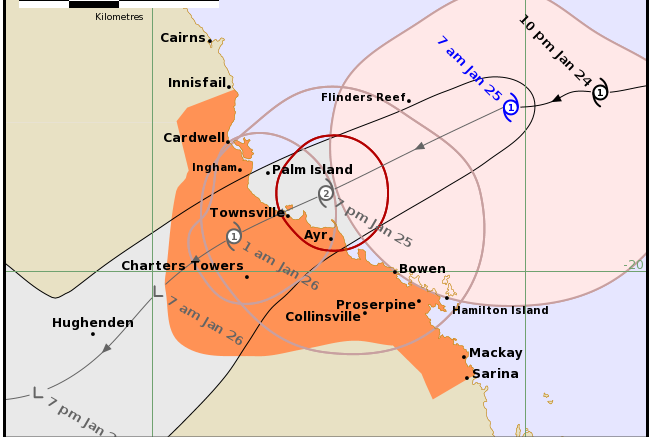
THE Bureau of Meteorology has officially named Tropical Cyclone Kirrily which is expected to cross the coast near Townsville tonight as a category 2.
Gales now occurring over Whitsunday Islands are due to extend to the mainland today.
The warning zone starts from Innisfail south to Sarina, including Townsville, Mackay, Bowen, the Whitsunday Islands, and extending inland to Charters Towers.
Heavy rainfall which may lead to flash flooding is likely to develop about coastal areas between Innisfail and Sarina during the day before spreading to inland areas late today and continuing during Friday.
“Intense rainfall which may lead to dangerous and life-threatening flash flooding is possible near the track of the system, most likely with the coastal crossing during tonight and Friday. A flood watch is also current for these areas,” the bureau said.
“During Friday, the system is expected to become a tropical low and heavy rainfalll may develop across the northern interior and western Queensland into the weekend as the system tracks inland.
“Tropical Cyclone Kirrily is expected to continue strengthening as it tracks west southwest towards the Queensland coast.
“The system will cross the Queensland coast tonight, in the vicinity of Townsville, as a category 2 system then weaken on Friday inland.
“From Friday, the system is likely to track further inland as a tropical low, resulting in heavy to intense rain to parts of the northern interior and western Queensland.
“Destructive wind gusts up to 140km/h are expected to develop about coastal and island communities between Ayr and Bowen, this evening, extending north to Ingham, including Townsville tonight.
- Boats and outside property should be secured using available daylight hours.
- For cyclone preparedness and safety advice, visit Queensland's Disaster Management Services website (www.disaster.qld.gov.au)
- For emergency assistance call the Queensland State Emergency Service (SES) on 132 500 (for assistance with storm damage, rising flood water, fallen trees on buildings or roof damage).
- If you choose to take shelter away from your home, stay COVID-19 safe and pack a mask and hand sanitiser (if you have them).
People between Innisfail and Ingham and between Bowen and Sarina, including Bowen, Mackay, and the Whitsunday Islands, should immediately commence or continue preparations, especially securing boats and property using available daylight hours.
People in inland areas to Charters Towers should take precautions and listen to the next advice.
- Information is available from your local government
- For cyclone preparedness and safety advice, visit Queensland's Disaster Management Services website (www.disaster.qld.gov.au)
- For emergency assistance call the Queensland State Emergency Service (SES) on 132 500 (for assistance with storm damage, rising flood water, fallen trees on buildings or roof damage).
- If you choose to take shelter away from your home, stay COVID-19 safe and pack a mask and hand sanitiser (if you have them).
A Bureau of Meteorology report said the system is forecast to track southwest, towards the Queensland coast, over the next few days as it intensifies.
“The system is forecast to cross the Queensland coast most likely overnight Thursday between Cardwell and Airlie Beach,” it said.
“The chance of a severe tropical cyclone on landfall remains but has decreased. From Friday, the system is forecast to move further south over inland parts as a tropical low.”
“Gales with damaging wind gusts up to 120 km/h may extend northward to coastal and island communities between Cairns and Townsville during Thursday.
“Destructive wind gusts up to 150 km/h may develop about coastal and island communities between Cardwell and Bowen including Townsville during Thursday.
“Heavy rainfall which may lead to flash flooding may develop about coastal areas between Townsville and St Lawrence from late Wednesday before spreading to adjacent inland areas and north to Cairns during Thursday and into Friday.
“Intense rainfall, which may lead to dangerous and life-threatening flash flooding is possible close to the system, most likely during Thursday.
“During Friday, the system is expected to become an inland rain depression and heavy rainfall may develop across central and southern inland areas, as well as southeast Queensland over the weekend as the system tracks south.
“People between Cairns to St Lawrence (not including Cairns), including Townsville, Mackay and the Whitsunday Islands, should consider what action they will need to take if the cyclone threat increases.
- Information is available from your local government
- For cyclone preparedness and safety advice, visit Queensland's Disaster Management Services website (www.disaster.qld.gov.au)
- For emergency assistance call the Queensland State Emergency Service (SES) on 132 500 (for assistance with storm damage, rising flood water, fallen trees on buildings or roof damage).
The severe weather system is currently in the Coral Sea and according to the Bureau of Meteorology (BOM) is likely to become a tropical cyclone tomorrow (Tuesday) to be named Kirrily.
The low is forecast to begin moving to the southwest later today, towards the east Queensland coast.
LDMG chairman Mayor Terry James said, while BOM’s tracking map currently predicted the system was more likely to impact areas south of Cairns, it was important that residents should remain vigilant and be prepared.
“As we have just experienced, weather systems are unpredictable and while its forecast track suggests an impact south of Cairns, it is a timely reminder to residents that we are still in the wet season and we need to be prepared at all times,” he said.
“I would urge residents to go over their household emergency plans and make sure they are familiar with the Cairns Disaster Dashboard.”
The Cairns Disaster Dashboard is a single point of reference for information and advice during a disaster. It brings information from Council, the Bureau of Meteorology, emergency services, utilities such as Ergon and Telstra, road status updates, and traffic and flood cams, together in one place.
Cr James said that floodwaters could also be affected by king tides, which were being experienced in Cairns this week, through to Saturday.
“Motorists should be aware that tidal flooding is saltwater, which can damage cars on contact. Avoid parking cars in low-lying tidal areas and never drive through floodwaters,” he said.
“Motorists are also being reminded to avoid driving in floodwaters and people advised to stay clear of stormwater drains and waterways.
“With wet weather forecast and local catchments already wet, as well as the impact of this week’s king tides, this can lead to significant amounts of fast-flowing water rushing into our water systems.”
Cr James said there were some parts of the community still dealing with the effects of last month’s flooding.
“I want to assure to residents that the LDMG is prepared should there be another event and that we are continuing to work with those people and communities impacted by last month’s flooding,” he said.
“Anyone who is feeling anxious, there is support is available by calling Lifeline on 13 11 14 or Beyond Blue on 1300 22 46 36.
“For a full list of available support services select the Community Relief tab on the Cairns Disaster Dashboard Recovery page.”
Cr James said that it was crucial that residents understood that there were different kinds of flooding, with Cairns most likely to be affected by storm surge and riverine flooding, as well as flash flooding.
“People need to understand that there are several different types of floods, and the damage each can do can be quite different,” he said.
“Knowing which type of flood could affect your home is key to knowing what you can do to prepare and ensure that you and your family are safe.”
Storm surge is caused when the pressure from a cyclone pushes down on the ocean surface forcing seawater onto land.
Importantly, Cr James reminded residents that in a cyclone, evacuation advice was given based on storm surge, not wind.
“Council has identified storm surge zones based on risk – the red zone is the highest risk area, closest to the coast, progressing to orange and yellow,” Cr James said.
Free sandbags are available for Cairns LGA residents to fill with sand on site from Council waste transfer stations.
“Residents in low-lying areas should prepare their properties for potential flooding,” Cr James said.
“Sandbags should be placed at least 3 courses high across doorways and other points where water can enter your home.”
Sandbags are for residential use only and scoops for filling will be provided.
Sandbags and sand will be available from the Portsmith, Smithfield, Gordonvale, and Babinda Transfer Stations, seven days a week, from 8.30am to 5.15pm, until supplies run out.
