General News
17 January, 2021
UPDATED 6AM- Cyclone Kimi downgraded to tropical low
Updated 6am Tuesday Jan 19. Cyclone Kimi has been downgraded is is not expected to cross the coast.
Details of Ex-Tropical Cyclone Kimi at 4:00 am AEST:
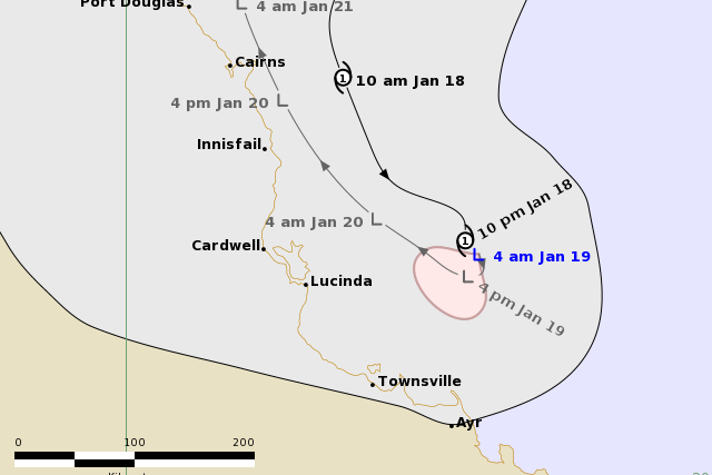
Cyclone Kimi has weakened to now be a tropical low of the coast from Townsville.
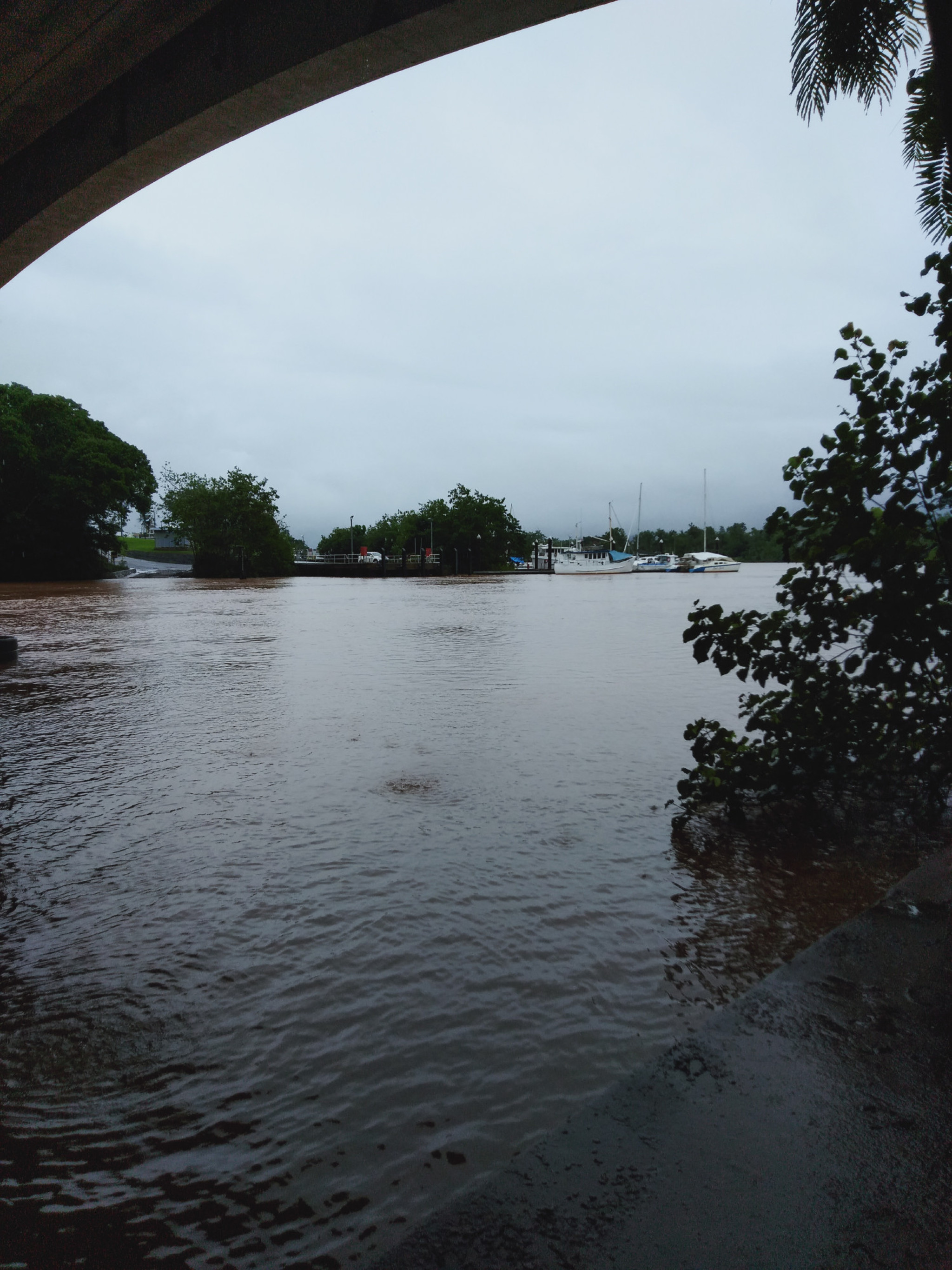
Whilst coastal communities have been spared the worst after Kimi remained off the coast and weakened, emergency services and Councils are warning residents there's still a risk of flooding and high winds.
Residents are advised to still exercise caution, monitor their council's Disaster Dashboards and do not attempt to drive through any floodwaters.
Intensity: tropical low, sustained winds near the centre of 65 kilometres per hour with wind gusts to 95 kilometres per hour.
Location: within 55 kilometres of 18.3 degrees South, 147.6 degrees East , 250 kilometres southeast of Cairns and 135 kilometres northeast of Townsville .
Movement: slow moving .
Cyclone Kimi has weakened into a remnant tropical low off the north Queensland coast.
The system is expected to remain slow-moving well off the coast through much of today, then begin tracking back towards the north-northwest from late this afternoon as a weak tropical low.
A coastal crossing as a tropical cyclone is no longer expected.
Hazards:
GALES are no longer expected about coastal and island areas.
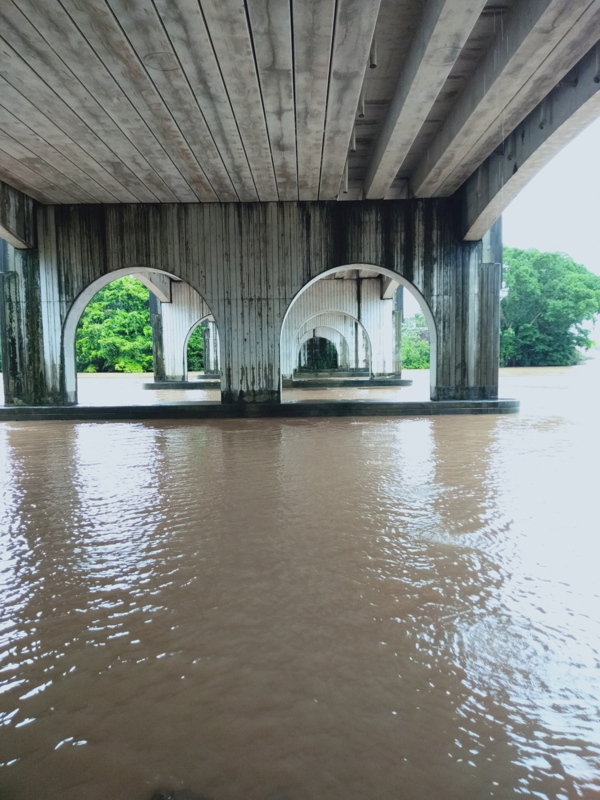
HEAVY RAINFALL with the potential to produce flash flooding and major river flooding may still affect coastal areas between Innisfail and Bowen on Tuesday and Wednesday if the remnant low moves closer to the coast. A Flood Watch is current for this area; refer to that product for more detail.
Tides will be slightly higher than normal between Bowen and Lucinda, however the sea level is not expected to approach the highest tide of the year.
Tropical Cyclone Kimi continues to baffle and surprise residents with it's unpredictability.
The latest Bureau of Metrology report issued just before 2pm today has the system continuing in a southerly direction to perform a 180 degree U-turn just north of Townsville before retuning back parallel to the coast as a tropical low.
Today the Cassowary Coast Regional Council urged residents to not be complacent and to stay aware of changing condition.
Residents along the coast are encouraged to check their local Disaster Dashboard to remain up to date with the ever changing situation.
The Cairns and Hinterland Hospital and Health Service are well prepared for the potential Impact of Tropical Cyclone Kimi.
A CHHHS spokesperson stated, "The Health Emergency Operations Centre established a specific incident team for the Cyclone on Sunday and is meeting regularly.
"Site preparations for flooding and high winds, and inventory checks have been completed at all our facilities, to ensure that we are ready to respond if circumstances change.
"Community members are reminded to stock up on any essential medical stocks.
"Our facilities are well prepared and ready to respond if required."
Cardwell and Ingham residents are keeping a close watch on the progress of Tropical Cyclone Kimi.
The system is currently 90 kilometres east of Cairns and moving at 12 kilometres an hour in a southward direction.
Based on the current forecast track, the cyclone may cross the coast overnight or Tuesday between about Innisfail and Lucinda, however there remains considerable uncertainty with the crossing time and location.
UPDATED 8am Monday January 18
The coming 24 hours will be critical as the Cassowary Coast prepared for yet another unwelcome visitor.
Cyclone Kimi, a Category 1 system continues to track south looking to reach landfall in the early hours of Tuesday morning.
Currently the system is 85 kilometres northeast of Cairns and moving at 9 kilometres per hour.
It is expected that the cyclone will trun south-southwest later today and cross the cost between Innisfail and Lucinda, although Cardwell is firming as Kimi's preferred destination.
The Bureau of Metrology have issued warning for the area.
DESTRUCTIVE WINDS with gusts to 140 km/h may develop about coastal and island areas between Innisfail and Lucinda on Monday evening or early Tuesday morning as the core of the cyclone approaches.
GALES with gusts to 120km/h may develop about coastal and island areas between Port Douglas and Innisfail during this morning, then extend inland to Mareeba and Atherton, and further south to Lucinda, later on Monday. Gales may also extend southwards to Townsville and Ayr early Tuesday depending on the movement of the cyclone.
HEAVY RAINFALL with the potential to produce flash flooding and major river flooding expected to affect coastal and adjacent inland areas between Cairns and Townsville during Monday and Tuesday. A Flood Watch is current for this area; refer to that product for more detail.
ABNORMALLY HIGH TIDES are likely today as the cyclone approaches the coast. A storm tide is possible between Yarrabah and Lucinda, but the sea level should not exceed the highest tide of the year. Large waves are likely along the beachfront.
END
Cyclone Kimi continues to travel slowly in a southwest direction, now positioned 110 kilometres in a northeast position off Cairns.
The current tracking has the system moving south before turning southwest to cross the coast between Innisfail and Cardwell.
Residents of the Cassowary Coast should log onto the Cassowary Coast Disaster Dashboard to stay up-to-date with roads, ergon, river heights and BOM notifications.
Intensity: category 1, sustained winds near the centre of 85 kilometres per hour with wind gusts to 120 kilometres per hour.
Location: within 20 kilometres of 16.3 degrees South, 146.6 degrees East , 110 kilometres northeast of Cairns and 330 kilometres north of Townsville .
Movement: south at 7 kilometres per hour .
Tropical cyclone Kimi moved slowly southwards through most of Sunday, but is expected to turn a little more to the south-southwest during today.
The system is most likely to approach, and may cross, the coast late today or early Tuesday between about Innisfail and Lucinda, however there remains considerable uncertainty with the crossing time and location.
The system may intensify further during today and is likely to be at least at least a category 2 system as it approaches the coast.
Hazards:
DESTRUCTIVE WINDS with gusts to 150 km/h may develop about coastal and island areas between Innisfail and Lucinda on Monday evening or early Tuesday morning as the core of the cyclone approaches.
GALES with gusts to 120km/h may develop about coastal and island areas between Port Douglas and Innisfail during Monday morning, then extend inland to Mareeba and Atherton, and further south to Lucinda, later on Monday. Gales may also extend southwards to Townsville and Ayr early Tuesday depending on the movement of the cyclone.
HEAVY RAINFALL with the potential to produce flash flooding and major river flooding expected to affect coastal and adjacent inland areas between Cairns and Townsville during Monday and Tuesday. A Flood Watch is current for this area; refer to that product for more detail.
ABNORMALLY HIGH TIDES are likely on Monday as the cyclone approaches the coast. A storm tide is possible between Yarrabah and Cardwell, where large waves may produce minor flooding along the foreshore. People living in areas likely to be affected by this flooding should take measures to protect their property as much as possible and be prepared to help their neighbours.
Updated 2am, Monday Jan 18
Tropical Cyclone Kimi now situated 140 kilometres northeast of Cairns continues to keep the Bureau of Metrology guessing as to where and when it will cross the coast.
Intensity: category 1, sustained winds near the centre of 85 kilometres per hour with wind gusts to 120 kilometres per hour.
Location: within 20 kilometres of 16.0 degrees South, 146.7 degrees East , 175 kilometres east southeast of Cooktown and 140 kilometres northeast of Cairns .
Movement: south southeast at 7 kilometres per hour .
Tropical cyclone Kimi has been moving slowly southwards through today, but is expected to turn a little more to the south-southwest during Monday.
The system is most likely to approach the coast late on Monday between about Cairns and Cardwell, however there remains considerable uncertainty with the crossing time and location.
The system may intensify further over the next 24 hours and is likely to be at least at least a category 2 system as it approaches the coast.
With the system tracking further south and with reduced impact upon the Douglas shire and the Daintree, the Daintree ferry will resume services from 6am today.
UPDATED: Sunday January 17, 8:07pm
Tropical Cyclone Kimi tracks further south and is set to cross the coast sometime tomorrow, Monday between Port Douglas and Innisfail.
Moving currently as a steady 6 kilometres per hour the system is still localed170 km northeast of Cairns, and 145 kilometres east of Cooktown.
Tropical Cyclone Kimi has sustained winds of 75 kilometres per hour near the centre and gusts to 100 kilometres per hour.
The system is due to intensify further in the next 24 hours and reach category 2 before landfall.
Currently Cairns Airport is operating normally as it monitors the cyclone as it started its preparations.
Flights into and out of Cairns Airport may be affected.
Passengers are urged to contact their airlines for information on specific flights, or to visit the airport website for flight information.
Residents are advised to monitor their local Council's Disaster Dashboards for up-to-the-minute information.
Cassowary Coast Disaster Dashboard
Cook Shire Council Disaster Dashboard
Tablelands Regional Council Disaster Dashboard
UPDATED 5:15PM SUNDAY
Tropical Cyclone Kimi continues to move slowly south with considerable uncertainty as to where and when it will cross the coast.
However the latest cyclone tracking map has Tropical Cyclone Kimi crossing the coast between Port Douglas and Cairns sometime tomorrow.
The predictions are that the system may intensify into a Category 2 before crossing the coast.
Cairns Regional Council continue to encourage residents to log onto the Cairns Disaster Dashboard to keep up to date with all road, electricity, BOM and Telstra notifications.
Links to all the local Council Disaster Dashboards can be found below:
Cassowary Coast Disaster Dashboard
Cook Shire Council Disaster Dashboard
Tablelands Regional Council Disaster Dashboard
UPDATED: 4:43pm Sunday
Cairns Disaster Dashboard the one-stop place for up-to-the-minute information
Cairns residents are being urged to familiarise themselves with the Cairns Disaster Dashboard.
The Cairns Disaster Dashboard (www.disaster.cairns.qld.gov.au) is a single point of reference for information and advice during a disaster.
It brings information from Council, the Bureau of Meteorology, emergency services, utilities such as Ergon and Telstra, road status updates, and traffic and flood cams, together in one place.
Cairns Local Disaster Management Group Chair Cr Terry James said the user-friendly dashboard allows residents to keep themselves informed during a natural disaster.
“During an emergency the dashboard is updated in real time with things like road closures, power outages and notifications of any shelters that may be opened,” Cr James said.
END
Updated: 3:47pm
Tropical Cyclone Kimi continues to track towards the Queensland coast, with an expected crossing between Port Douglas and the Daintree.
A warning has been issued from Cape Lenville to Cardwell.
Tropical Cyclone Kimi is a Category 1 cyclone, with sustained winds near the centre of 75km/hr, and wind gusts expected up to 100 km/hr.
The cyclone is located 135 km east of Cooktown and is moving south at 11 km/hr.
Intensity: Category 1, sustained winds near the centre of 65 kilometres per hour with wind gusts to 95 kilometres per hour.
Location: within 45 kilometres of 14.9 degrees South 146.4 degrees East, estimated to be 140 kilometres east northeast of Cooktown and 235 kilometres north northeast of Cairns.
Movement: southwest at 9 kilometres per hour.
Tropical cyclone Kimi has formed in the northwest Coral Sea northeast of Cooktown. The cyclone is expected to move to the southwest and cross the north tropical coast between Cape Flattery and Port Douglas on Monday morning. It may reach category 2 before crossing.
DESTRUCTIVE WINDS with gusts to 130 km/h may develop about coastal and island areas between Cape Flattery and Cairns from early Monday morning as the cyclone approaches.
GALES with gusts to 120km/h may develop about coastal and island areas between Cape Melville and Cardwell from Sunday evening. These GALES may extend inland to Palmerville and Chillagoe on Monday as the cyclone moves inland.
HEAVY RAINFALL is forecast to develop about coastal and adjacent inland areas between Cape Flattery and Cardwell from Sunday afternoon. A Flood Watch is current for this area; refer to that product for more detail.
ABNORMALLY HIGH TIDES are likely on Sunday night and Monday as the cyclone approaches, however they are unlikely to exceed the highest tide of the year.
RELATED: Prepare in advance.
Cairns Prepares for the coming cyclone.
The Cairns Regional Council has advised the Cairns Botanic Gardens and the Arrow tracks will close from 3pm Sunday due to the possible impact from Cyclone Kimi.
In a statement, released this afternoon, the Council Regional Council said both sites would remain closed until further notice.
Reopening of the sites occur once they are deemed safe to use.
Residents between Cape Melville and Cardwell should start or continue with their preparations. Boast should be be securely moored and properties should be prepared in readiness of the cyclone.
Monitor the Disaster Dashboard in your local council area for up-to-the-date notification.
Cassowary Coast Disaster Dashboard
Cook Shire Council Disaster Dashboard
Tablelands Regional Council Disaster Dashboard
For cyclone preparedness and safety advice, visit Queensland’s Disaster Management Services website.
