General News
27 January, 2021
Far North on Cyclone Alert
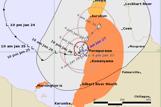
THE Bureau of Meteorology has now declared a warning zone for Cape York Peninsula communities as an intensifying tropical low is forecast to become a category one cyclone on Thursday.
Issued 4:49am Wed January 27
THE Bureau of Meteorology has now declared a warning zone for Cape York Peninsula communities as an intensifying tropical low is forecast to become a category one cyclone on Thursday.
A warning zone is in place for Mornington Island, and Karumba to Aurukun, including Kowanyama and Pormpuraaw, and nearby inland areas.
A watch zone is in place for Aurukun to Weipa.
“The tropical low is expected to remain slow-moving off the Western Cape York Peninsula coast and develop into a tropical cyclone on Thursday,” the bureau’s advice read.
“The system should remain slow-moving in the southeastern region of the Gulf of Carpentaria for a few days, after which it may cross the Western Cape York Peninsula coast.”
The tropical low had sustained winds near the centre of 45 kilometres per hour with wind gusts to 85 kilometres per hour.
It was estimated to be 75 kilometres north northwest of Kowanyama and 310 kilometres northeast of Mornington Island, moving east northeast at 8km/h.
Next Advice: 8am Wednesday January 27
RELATED:Prepare in advance
Hazards:
Heavy rainfall is forecast about western parts of Cape York Peninsula for the next several days with the potential for 150 to 200 millimetres per day for multiple days. The most likely areas to see these rainfall totals will be coastal parts between Weipa and Gilbert River Mouth.
Abnormally high tides are expected between the Torres Strait Islands and the Gilbert River Mouth during the next several days due to persistent monsoonal westerly flow and the developing tropical low. Tides rising above the normal high tide level are expected on Wednesday’s and Thursday’s high tides. Large waves may produce minor flooding along the foreshore. People living in areas likely to be affected by this flooding should take measures to protect their property as much as possible and be prepared to help their neighbours. A separate Severe Weather Warning is current for these conditions.
Gales with gusts to 110 kilometres per hour may develop about Mornington Island, and communities between Aurukun to Karumba, and nearby inland areas, on Thursday morning.
Destructive winds with gusts to 150 kilometres per hour may develop from Thursday night if the system continues to intensify.
Gales may extend north to areas between Aurukun and Weipa later on Thursday or on Friday if the system follows a more northward track.
RELATED:Get your supplies ready
Recommended Action:
People on Mornington Island, and between Aurukun and Karumba, and nearby inland areas should immediately commence or continue preparations, especially securing boats and property.
– If you choose to take shelter away from your home, stay COVID-19 safe and pack a mask and hand sanitiser (if you have them).
People between Aurukun and Weipa should consider what action they will need to take if the cyclone threat increases.
– Information is available from your local government
– For cyclone preparedness and safety advice, visit Queensland’s Disaster Management Services website (www.disaster.qld.gov.au)
– For emergency assistance call the Queensland State Emergency Service (SES) on 132 500 (for assistance with storm damage, rising flood water, fallen trees on buildings or roof damage).
RELATED:Get ready for storm season
